
After I spent half an hour tracing borders? I hope not!Kaplowitz wrote:Hey Oaktown, you wanna post the PSD?

Holiday Mapmaking Competitions!
Moderator: Cartographers
Forum rules
Please read the community guidelines before posting.
Please read the community guidelines before posting.
Re: Holiday Mapmaking Competitions!

Re: Holiday Mapmaking Competitions!
Hmm, to put everybody on an even playing field I think I shouldn't... some folks may not be working in photoshop.Kaplowitz wrote:Hey Oaktown, you wanna post the PSD?
-
e_i_pi

- Posts: 1775
- Joined: Tue Feb 12, 2008 2:19 pm
- Location: Corruption Capital of the world
- Contact:
Re: Holiday Mapmaking Competitions!
I think this is a good decision. I work in Photoshop, and while a PSD file might be handy, it also circumvents some of the process, and so could give an unfair advantage. I'm sure everyone will be able to come up with something in the time though, and I look forward to seeing what everyone else createsoaktown wrote:Hmm, to put everybody on an even playing field I think I shouldn't... some folks may not be working in photoshop.Kaplowitz wrote:Hey Oaktown, you wanna post the PSD?
-
samuelc812

- Posts: 2215
- Joined: Sun Dec 30, 2007 6:56 am
- Gender: Male
Re: Holiday Mapmaking Competitions!
ZeakCytho wrote:After I spent half an hour tracing borders? I hope not!Kaplowitz wrote:Hey Oaktown, you wanna post the PSD?
I don't think you can participate in Central America as you already have a quenched map

Re: Holiday Mapmaking Competitions!
Not sure Zeak counts - as he's not made GFX before...samuelc812 wrote:ZeakCytho wrote:After I spent half an hour tracing borders? I hope not!Kaplowitz wrote:Hey Oaktown, you wanna post the PSD?
I don't think you can participate in Central America as you already have a quenched map
As much as I would call that I could possibly enter both - I've never done GFX before - but have multiple quenched maps!?
(Not that I'm going to - as my GFX Sucks - although I might be able to come up with a theme for Centrescape)
C.

Highest score : 2297

Re: Holiday Mapmaking Competitions!
http://img.photobucket.com/albums/v450/ ... 1227273312wcaclimbing wrote:I found a miniature version at: http://www.boardgamebeast.com/online-bo ... -risk.html
Thank you google.
There's the risk version of this map. Our old map looked similar, but different enough imo. But alas.. the big boys thought differently. Anyway - you can maybe draw inspiration from the "feel" of this map anyway. Obviously too much detail for our computer screen resolutions, but nevertheless, a sweet map!

-
e_i_pi
- Posts: 1775
- Joined: Tue Feb 12, 2008 2:19 pm
- Location: Corruption Capital of the world
- Contact:
Re: Holiday Mapmaking Competitions!
Q: Should we send our images in large or small format?
Re: Holiday Mapmaking Competitions!
MrBenn wrote:I imagine either would be fine, but if in doubt, go for the small first.ZeakCytho wrote:Is there a preference on whether we submit a large or small version?
Re: Holiday Mapmaking Competitions!
Some prefer to work in small since you avoid the hassle of going back in and trying to make everything fit when you scale down, but as this is a competition you my achieve greater visual impact with the large. Your call.e_i_pi wrote:Q: Should we send our images in large or small format?
Re: Holiday Mapmaking Competitions!
What Yeti said - I PMed Oaktown before starting - since I've never done graphics before, I'm an amateur still.samuelc812 wrote:ZeakCytho wrote:After I spent half an hour tracing borders? I hope not!Kaplowitz wrote:Hey Oaktown, you wanna post the PSD?
I don't think you can participate in Central America as you already have a quenched map
-
AndyDufresne

- Posts: 24935
- Joined: Fri Mar 03, 2006 8:22 pm
- Location: A Banana Palm in Zihuatanejo
- Contact:
Re: Holiday Mapmaking Competitions!
Good luck everyone! I'm excited to see these competitions underway. We've just linked a Headline on the Homepage, so hopefully we'll draw in a few people.
--Andy
--Andy

Re: Holiday Mapmaking Competitions!
unfortunately in these competitions, doing the small has no benefit. other people's maps will look better because they are large and any possible complications from downsizing the map will be ignored.
I personally find it quite silly that everyone is not forced to make the small version since this is what we're told the majority of the people on CC use.
I personally find it quite silly that everyone is not forced to make the small version since this is what we're told the majority of the people on CC use.
-
Ditocoaf
- Posts: 1054
- Joined: Wed Feb 27, 2008 9:17 pm
- Location: Being eaten by the worms and weird fishes
Re: Holiday Mapmaking Competitions!
Really? I hate the small versions. I prefer the clarity of using a full-sized map, and always considered the small maps to be scaled-down thumbnail versions for people with tiny screens. Saved screen space in exchange for loss of detail and aesthetics.edbeard wrote:unfortunately in these competitions, doing the small has no benefit. other people's maps will look better because they are large and any possible complications from downsizing the map will be ignored.
I personally find it quite silly that everyone is not forced to make the small version since this is what we're told the majority of the people on CC use.

>----------✪ Try to take down the champion in the continuous IPW/GIL tournament! ✪----------<
Note to self: THINK LESS LIVE MORE
-
Sir. Ricco

- Posts: 4555
- Joined: Tue Oct 02, 2007 2:33 pm
- Gender: Male
- Location: Making kingdoms burn and bloodshed start.
- Contact:


-
BENJIKAT IS DEAD

- Posts: 775
- Joined: Sun Jan 06, 2008 9:47 am
- Location: Waterloo
Re: Holiday Mapmaking Competitions!
I totally agree with this - I would love to see everyone have to make the small map, but unless it is a requirement, then you would be disadvantaging yourself by doing so.edbeard wrote:unfortunately in these competitions, doing the small has no benefit. other people's maps will look better because they are large and any possible complications from downsizing the map will be ignored.
I personally find it quite silly that everyone is not forced to make the small version since this is what we're told the majority of the people on CC use.
I always use the small maps (yes, even for my 100s of games on Waterloo, supermax etc etc)... as I find most of the large maps too spread out to easily gauge different player's drop density (where they are positioned most etc)...

Re: Holiday Mapmaking Competitions!
I believe the last time we had the stats shared - only 10% of users had the Large map set as default...Ditocoaf wrote:Really? I hate the small versions. I prefer the clarity of using a full-sized map, and always considered the small maps to be scaled-down thumbnail versions for people with tiny screens. Saved screen space in exchange for loss of detail and aesthetics.edbeard wrote:unfortunately in these competitions, doing the small has no benefit. other people's maps will look better because they are large and any possible complications from downsizing the map will be ignored.
I personally find it quite silly that everyone is not forced to make the small version since this is what we're told the majority of the people on CC use.
Of course that doesn't count the people that don't have it set to default and select it each time!!
But I can't imagine that is 40% of people?!
Note - this is a similar reason as to why we aren't allowed to use larger maps etc.
C.
Highest score : 2297
-
whitestazn88
- Posts: 3128
- Joined: Mon Feb 05, 2007 2:59 pm
- Gender: Male
- Location: behind you
- Contact:
Re: Holiday Mapmaking Competitions!
I'll put my money on RJ winning another revamp competition...
that is, if he decides to submit a map.
that is, if he decides to submit a map.
Re: Holiday Mapmaking Competitions!
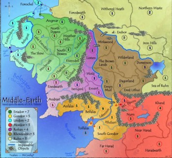
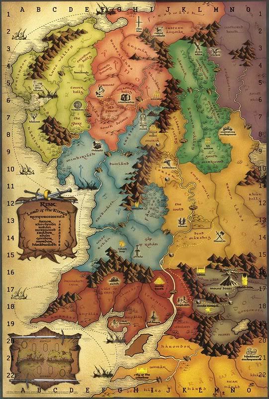
Speaking as a mapmaker and not as CA, can I mention that the connectivity is whack on the Centrescape/Middle Earth map? So many impassable barriers - mountains, rivers, ocean - it's a bitch to make it fit over anything else!
-
wcaclimbing
- Posts: 5598
- Joined: Fri May 12, 2006 10:09 pm
- Location: In your quantum box....Maybe.
- Contact:
Re: Holiday Mapmaking Competitions!
Yep... I'm encountering that problem right now....oaktown wrote:Speaking as a mapmaker and not as CA, can I mention that the connectivity is whack on the Centrescape/Middle Earth map? So many impassable barriers - mountains, rivers, ocean - it's a bitch to make it fit over anything else!
This will be interesting...

Re: Holiday Mapmaking Competitions!
whitestazn88 wrote:I'll put my money on RJ winning another revamp competition...
that is, if he decides to submit a map.

Re: Holiday Mapmaking Competitions!
I agree with Oaktown on this one... I just cannot get the layout to fit onto my basemap on the idea I've tried to pull off...oaktown wrote:Speaking as a mapmaker and not as CA, can I mention that the connectivity is whack on the Centrescape/Middle Earth map? So many impassable barriers - mountains, rivers, ocean - it's a bitch to make it fit over anything else!
Back to the drawing board...
PS... If you wanted to help advertise the foundry competitions, please free to sport the Competition Signature:
Code: Select all
[url=http://www.conquerclub.com/forum/viewtopic.php?f=10&t=70130][img]http://i275.photobucket.com/albums/jj320/bpawley/cc/ChristmasCompBanner.png[/img][/url]
PB: 2661 | He's blue... If he were green he would die | No mod would be stupid enough to do that
Re: Holiday Mapmaking Competitions!
Yep, I've already scrapped one idea, and I'm trying to force idea #2 to work. How damned annoying is the gap between G3, G4, G5, and G6?MrBenn wrote:Back to the drawing board...
Having never actually played the original map, I'm beginning to wonder if this is all worth it!
-
e_i_pi
- Posts: 1775
- Joined: Tue Feb 12, 2008 2:19 pm
- Location: Corruption Capital of the world
- Contact:
Re: Holiday Mapmaking Competitions!
Same, though I'm on the other map. I started one rendition of Central America, had space issues when it came to certain provinces, and have started again from scratch - this is after tracing out all the borders lol. Thankfully though, the title and army circles don't have to be re-done hehehe. I'm loving the time critical nature of this comp 
Re: Holiday Mapmaking Competitions!
I think it would be fair to fudge the borders a bit in Central America in order to make things fit, much as was done with the Brazil competition. The key is keeping the gameplay the same, so if a territory isn't the exact shape as the original yet still has all of the same bordering territories I doubt anybody will notice.e_i_pi wrote:Same, though I'm on the other map. I started one rendition of Central America, had space issues when it came to certain provinces, and have started again from scratch - this is after tracing out all the borders lol. Thankfully though, the title and army circles don't have to be re-done hehehe. I'm loving the time critical nature of this comp
-
e_i_pi
- Posts: 1775
- Joined: Tue Feb 12, 2008 2:19 pm
- Location: Corruption Capital of the world
- Contact:
Re: Holiday Mapmaking Competitions!
With all due respect oaktown, I'd like to keep the real world borders and regional boundaries as isoaktown wrote:I think it would be fair to fudge the borders a bit in Central America in order to make things fit, much as was done with the Brazil competition. The key is keeping the gameplay the same, so if a territory isn't the exact shape as the original yet still has all of the same bordering territories I doubt anybody will notice.e_i_pi wrote:Same, though I'm on the other map. I started one rendition of Central America, had space issues when it came to certain provinces, and have started again from scratch - this is after tracing out all the borders lol. Thankfully though, the title and army circles don't have to be re-done hehehe. I'm loving the time critical nature of this comp